

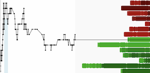


TUCSON, AZ / ACCESSWIRE / January 17, 2023 / Western Alaska Minerals (the "Company" or "WAM") (TSXV:WAM) is pleased to announce that massive sulfides announced visually from drill hole WPC22-21 (See News Release of September 22, 2022) report 5.1 meters grading 789 g/t Silver (25.4 oz/t), 22.0% Lead and 14.9% Zinc. WPC22-21 is the last hole to be reported from the 2022 exploration season at WAM's 100% owned Waterpump Creek Carbonate Replacement Deposit (CRD), and successfully continues the emerging 400m long mineralized trend defined by holes WPC21-09 through WPC22-22 (See Press Release September 22, 2022 and Table 2 below). Mineralization remains open in several directions and tracing this mineralized body will be one of the principal focuses of an expanded 2023 drill program.
Table 1. Composite results from drill hole WPC22-21**. All Waterpump Creek results can be found on our website along with more technical information.
DH | From (m) | To (m) | Width m* | Ag g/t | Ag opt | Pb % | Zn % |
WPC22-21 | 150.0 | 155.1 | 5.1 | 789 | 25.4 | 22.0 | 14.9 |
* Width reported as core length
** Previously visual release ( 9/22/2022) reported 4.0 meters of width
"Bonanza silver grades averaging 25.4 oz/T with combined lead-zinc grades of 36.9% in the last hole of our 2022 drilling program are a great way to end the season," said Kit Marrs, CEO. "This intercept continues the upper zone or manto at Waterpump Creek and mirrors similar high-grades in drill holes extending approximately 400 meters to the north. We expect to continue expanding the zone to the south with an aggressive multi-rig program in 2023."
Highlights of the 2022 Drilling Program (Summarized in Table 2)
- The emerging Waterpump Creek Manto shows classic multi-phase CRD-style massive sulfide mineralization with silver-rich lead stages cutting earlier zinc-rich stages and late-stage pyritic zones cutting the earlier silver and base metal zones.
- Similar mineralization has now been cut at similar elevations in 10 WAM drill holes (including WPC21-09) and 6 historical drill holes, indicating a continuous elongate body 30 to 75 meters wide and 400 meters in length (See Figure 2).
- Mineralization along the body thickens progressively from north to south towards WPC22-18, which cut 101.7m of massive and semi-massive sulfides at the intersection of the Waterpump Creek graben structure and the Illinois Creek fault. This is interpreted as a feeder chimney to the laterally developed manto mineralization.
- The high-grade intercepts in WPC22-13, 17, 20, 21 and 22 appear linkable to the high-grade zones in the interpreted WPC22-18 chimney.
- WPC22-22 cut three significant zones of massive to semi-massive sphalerite and argentiferous galena in a matrix of secondary dolomite like that seen in previous drilling (See Press Release of December 7, 2022).
- Deep sulfide intercepts in WPC22-22 lie at greater depth than WPC22-17 and 21 indicating that similar mineralization may be present below both of these holes (see Figure 1. Cross Section 7104900N).
"The emerging Waterpump Creek manto is a beautiful example of the high-grade, multi-stage mineralization features characteristic of a large CRD system," said Dr. Peter Megaw, WAM's Exploration Advisor. "Next we need to continue tracing this mineralization towards its source and seeing if we can leapfrog that process by locating the source with geophysics and surface geochemistry."
Table 2. Summary of mineralized intercepts from 2022 drill program.
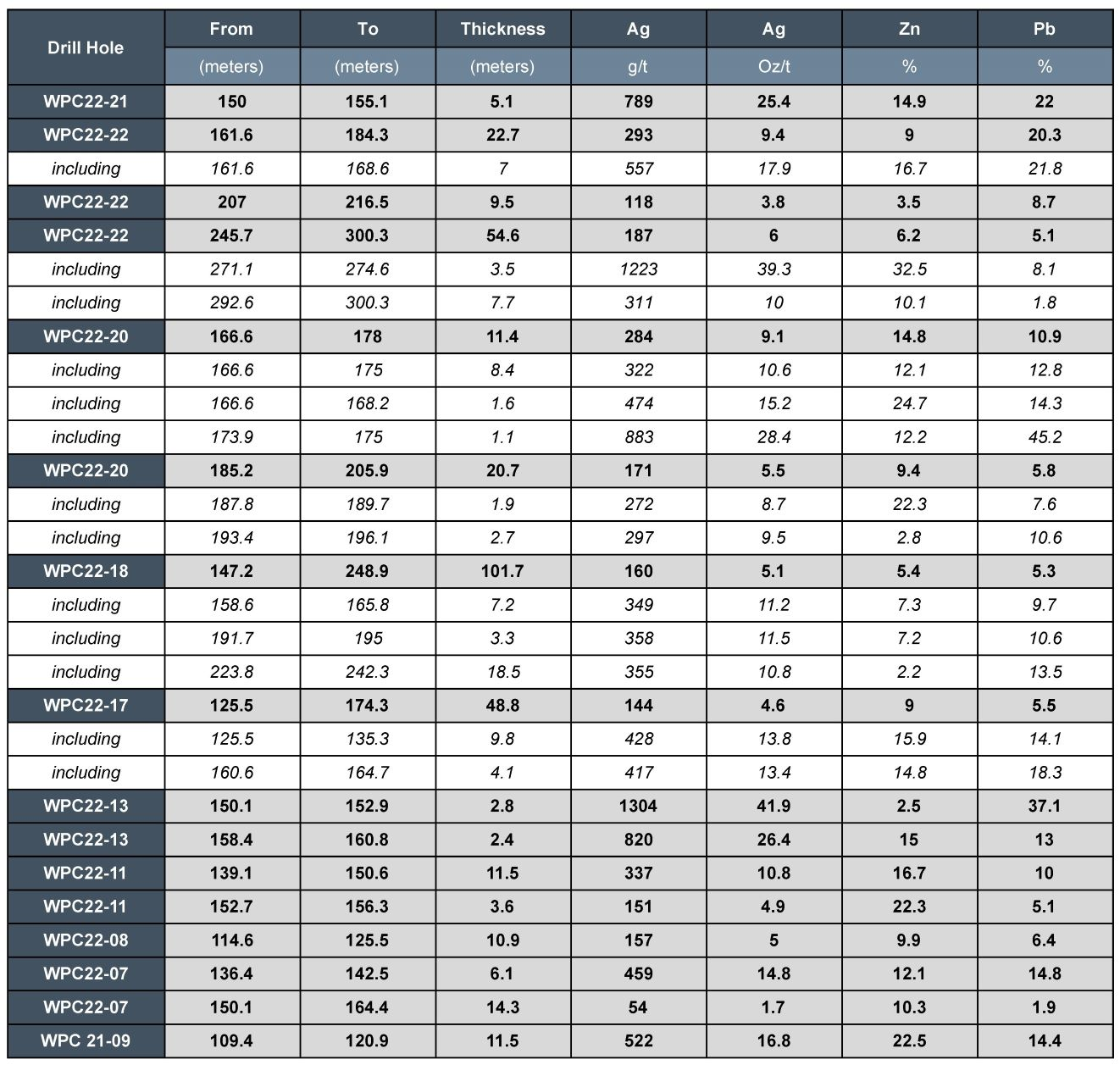
Waterpump Creek Drilling: 2022 Summary and Discussion
Twenty-eight holes were drilled at Waterpump Creek in 2022. Of the 28holes, 9 encountered mineralization (see Table 2), and the remainder did not. Given the sinuous, "skeletal" nature of many CRD deposits and the sharp boundaries between mineralized and non-mineralized material in CRD's, this is not an unexpected result. Of those holes which did not encounter mineralization, 12 were drilled off to the east or west sides of the manto and two missed by drilling above or below the mineralized holes detailed in Table 2, and five were located on the south side of intervening wetlands along an east-west line located approximately 150 meters south of WPC22-22. These five holes suggest the manto is further west as a consequence of the intersection with the north-east trending Illinois Creek fault zone. This conclusion is also supported by ongoing remodeling of the 2005 IP survey and will be verified during the 2023 drill program.
Combining the results from the first 23 holes drilled in the Waterpump Creek structural zone allows delineation of a continuous elongate massive sulfide ribbon ("manto") 30 to 75 meters wide and 400 meters in length plunging gently to the south (Figures 1 and 2). Mineralization remains open in several directions. The mineralization affects reactive dolomite lying beneath an impermeable schist along the WPC Creek structure. Hole WPC22-18 tested the intersection of the WPC and Illinois Creek structures and cut 101.7 meters of massive and semi-massive sulfides interpreted to reflect a "feeder chimney" and a possible mineralizing fluid upwelling zone. The three emerging mantos of high-grade silver-lead-zinc mineralization in WPC22-22 extend the lower mineralized zone 75 meters south of WPC22-18 and suggest it continues to thicken in that direction.
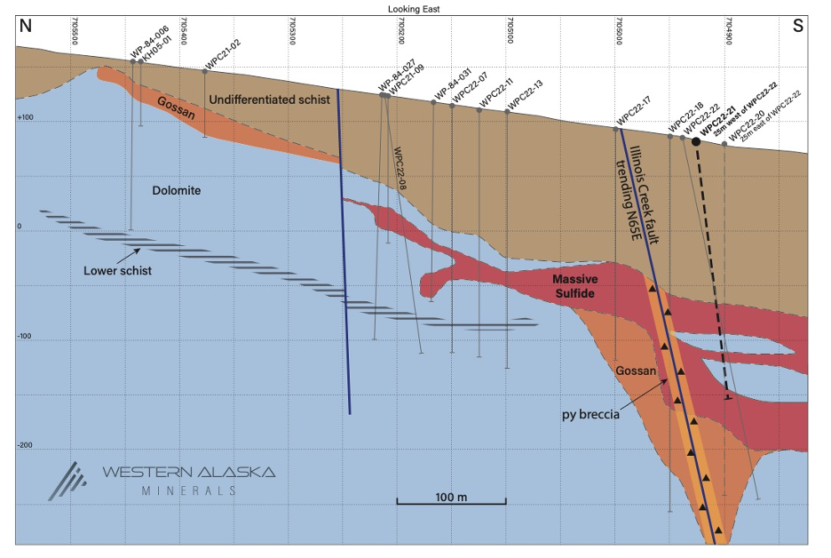
Figure 1. Updated longitudinal-section along the axis of the Waterpump Creek manto showing its position beneath the overlying schist and progressive thinning to the north from the WPC22-18 Chimney. Note how the manto maintains very significant thickness to the south into WPC22-22 and how the highest-grade upper part of the manto can be traced continuously for 400 meters. Note also the pyrite zone concentrated along the interpreted Illinois Creek Fault and how late movements along the fault have allowed surface waters to infiltrate and oxidize the pyrite and surrounding sulfides to a massive gossan. WPC22-21 is located on Line 4900 N and is 25 meters in front (west) of the section, therefore it is not exactly represented in Figure 1. Note also how it was stopped short of the deeper mineralization cut subsequently in WPC22-22.
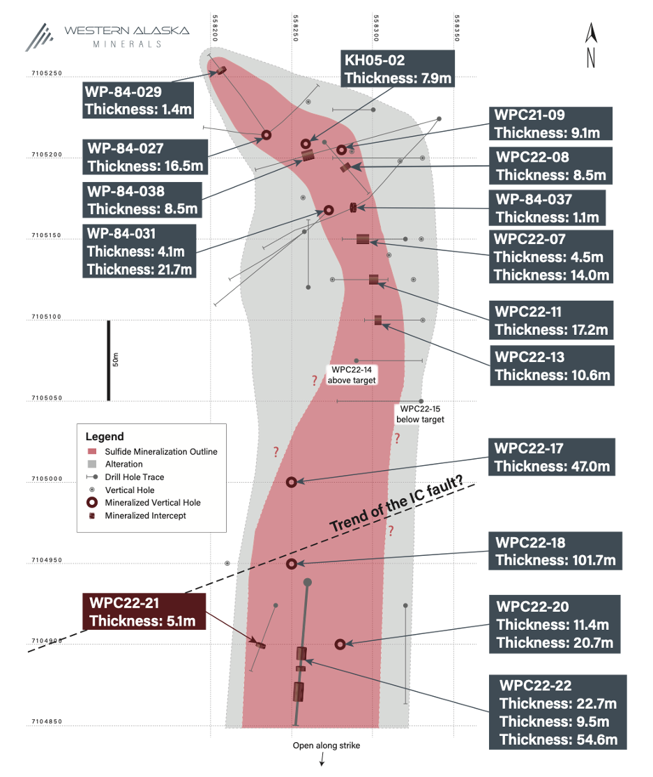
Figure 2. Pierce point plan map of Waterpump Creek drilling showing the emerging shape of the Waterpump Creek Manto and the location of the WPC22-18 Chimney at the interpreted intersection of the WPC Graben and the projected trend of the Illinois Creek fault. Note the continuation of strong manto mineralization to the south into WPC22-20 and 22 and that the manto remains open to the south along this principal axis as well as laterally.
Plans Going Forward:
Planning for 2023 is ongoing as this year's results are analyzed in detail. Two or three new Company-owned drill rigs are expected to be added to the two existing owned drill rigs allowing WAM to drill up to 17,000 meters next season. 2023 drilling will focus on following the Waterpump Creek high-grade manto to extend the manto along strike with drill spacings ultimately suitable for resource modeling. Concurrently, we will explore via drilling and geophysics the multiple similar geologic settings which have been identified elsewhere on the property and look for the intrusive body that drove the system.
CRD Background
To better understand more details and the implications of WAM's ongoing CRD exploration atWaterpump Creek and the greater Illinois Creek District, more technical details on the project and a brief discussion on CRD geometries, zoning, and scale is available on our website.
Qualified Person
Stuart Morris, P. Geo., is the qualified person as defined under National Instrument 43-101 that reviewed and approved the technical disclosures in this release. Mr. Morris is an independent consultant, Registered Geologist with the British Columbia Association of Professional Engineers and Geoscientists (BC-APEG) No. 135066 and with the Arizona State Board of Technical Registration No. 16289. Mr. Morris has a MS in Economic Geology and 40 plus years of experience in mineral resources, mine, and exploration.
His review verified the data disclosed, including geology, sampling, analytical and QA/QC data underlying the technical information in this news release, including reviewing the reports of ALS, methodologies, results, and all procedures undertaken for quality assurance and quality control in a manner consistent with industry practice.
Quality Assurance/Quality Control
Quality Assurance/Quality Control of drill sample assay results are independently monitored through a quality assurance/quality control ("QA/QC") protocol which includes the insertion of blind standard reference materials, blanks, and duplicates samples at regular intervals.
Core logging and sampling is completed at the Illinois Creek mine camp in Alaska. Drill core is logged under an established procedure using Geospark commercial logging software. Core interval selected for assay are sawn lengthwise in half. One half of the core interval is bagged and labeled for assay. The remainder is stored on site for reference. The bagged core samples are transported to ALS facilities in Fairbanks, Alaska from Illinois Creek under a strict chain of custody security protocol. At ALS each half-core sample is crushed and pulverized to pulps. The pulps are then split to the appropriate measured weights for the designated analytical analysis. The pulps are then sent to the ALS laboratory in Vancouver, Canada, for analysis. The gold content is determined by fire assay of a 30-gram charge with an AA finish. Silver, lead, copper, and zinc along with other elements are analyzed by ICP utilizing a four-acid digestion. Over-limit samples for silver, lead, copper, and zinc are determined by ore-grade titration analyses. ALS Inc. is independent of Western Alaska Minerals and its affiliates.
ALS Laboratory's also performs its own internal QA/QC procedures to assure the accuracy and integrity of results. Parameters for ALS' internal and WAM' external blind quality control samples are acceptable for the elements analyzed. WAM is unaware of any drilling, sampling, recovery, or other factors that could materially affect the accuracy or reliability of the data referred to herein.
About WAM
WAM is an Alaska and Arizona based company, listed on the TSX-V and focused on discovery of high-grade, district-scale ore systems in the historic Illinois Creek Mining District located in western Alaska. WAM's 100% owned claims cover 73,120 acres (114.25 square miles or 29,591 hectares), roughly 45 km from the Yukon River. The District encompasses at least five deposits containing gold, silver, copper, lead, and zinc and was originally discovered by Anaconda Minerals Co. in the early 1980's. Since 2010, WAM, along with precursor Western Alaska Copper & Gold Company, has reassembled the Anaconda property package and been engaged in exploring the District.
The Company currently has approximately 23,810,804 common shares issued and outstanding and 224,801 proportional shares issued and outstanding. Each proportional share is convertible to 100 common shares at the request of the shareholder and in the discretion of the Company. Because of these conversion rights, for market capitalization and financial analysis purposes, it is appropriate to convert the proportional shares to common shares and add the product of the conversion to the current number of common shares outstanding. When doing so, the sum of the approximate number of common shares (23,810,804) and converted proportional shares (22,480,100) equals 46,290,904 shares. Further information regarding the Company's share structure is available upon request.
On behalf of WAM
"Kit Marrs"
Kit Marrs
President & CEO
Phone: (520) 200-1667
For further information please contact:
Vanessa Bogaert, Director of Corporate Communications/IR at vanessa@westernalaskaminerals.com
Or visit our website at: www.westernalaskaminerals.com
Forward Looking Information
Certain statements made, and information contained herein may constitute "forward looking information" and "forward looking statements" within the meaning of applicable Canadian and United States securities legislation. These statements and information are based on facts currently available to the Company and there is no assurance that actual results will meet management's expectations. Forward-looking statements and information may be identified by such terms as "anticipates", "believes", "targets", "estimates", "plans", "expects", "may", "will", "could" or "would". Forward-looking statements and information contained herein are based on certain factors and assumptions regarding, among other things, the estimation of mineral resources and reserves, the realization of resource and reserve estimates, metal prices, taxation, the estimation, timing and amount of future exploration and development, capital and operating costs, the availability of financing, the receipt of regulatory approvals, environmental risks, title disputes and other matters. While the Company considers its assumptions to be reasonable as of the date hereof, forward-looking statements and information are not guaranteeing of future performance and readers should not place undue importance on such statements as actual events and results may differ materially from those described herein. The Company does not undertake to update any forward-looking statements or information except as may be required by applicable securities laws.
Neither TSX Venture Exchange nor its Regulation Services Provider (as that term is defined in the policies of the TSX Venture Exchange) accepts responsibility for the adequacy or accuracy of this release.
SOURCE: Western Alaska Minerals
View source version on accesswire.com:
https://www.accesswire.com/735420/Western-Alaska-Minerals-Announces-Bonanza-Grades-from-Waterpump-Creek-WPC22-21-51-Meters-Grading-789-gt-Silver-254-ozt-220-Lead-and-149-Zinc-And-2022-Waterpump-Creek-Drilling-Summary

