


TUCSON, AZ / ACCESSWIRE / December 7, 2023 / Western Alaska Minerals (the "Company" or "WAM") (TSX-V:WAM) is pleased to provide an exploration summary for 2023 work completed on its 100% owned, 30,000-hectare Illinois Creek ("IC") Carbonate Replacement Deposit ("CRD") project in central Alaska.
The project hosts a continuous six-kilometer corridor of CRD-style alteration, favorable structure, and permissive stratigraphy linking the past-producing gold-silver Illinois Creek Mine ("ICM") in the southwest and the high-grade silver-lead-zinc Waterpump Creek ("WPC") massive sulfide CRD deposit in the northeast (Figure 1).
The 2023 drilling season dedicated 5 holes totaling 1,706 meters to expand the high-grade sulfide mineralization at Waterpump Creek and 3,412 meters in 9 holes to seek mineralization 700 meters to the south across a post-mineral fault into the Last Hurrah target area where geophysics, surface sampling, and historical drilling indicated the mineralized corridor runs.
Waterpump Creek drilling extended massive sulfide mineralization at least 45 meters down-plunge to the south and demonstrates lateral continuity of the mineralization for 495 meters to where the body is apparently displaced by an ENE-WSW trending fault. The best hole in 2023 was WPC23-30, ( See press release dated August 14 ) which cut 40.2 meters core width (37.8 meters true width) of 262 g/t Ag (8.4 opt), 10.9% Pb and 4.5% Zn, including: 5.3 m of 729 g/t Ag (23.4 opt), 24.1% Pb and 3.1 % Zn, and 8.6 m of 493 g/t Ag (15.8 opt), 22.9% Pb and 2.6% Zn. Drilling then moved to Last Hurrah, testing the continuation of WPC mineralization across the post-mineral fault. The drill holes there yielded broad zones of CRD alteration with dispersed mineralization, which correlate well with 2005 and 2023 geophysical models. More importantly, 2 of the 3 Last Hurrah holes that were drilled through an underlying impermeable schist, hit similar alteration in a limestone unit. This indicates that mineralization may also occur in this deeper unit, opening it for exploration across the property (Figures 1-3). The technical team is integrating these results into an enhanced district model, including reinterpretation of the geophysics, in preparation for drilling next season.
"It is rare for a junior exploration company to control, in a stable mining jurisdiction, an entire, intact system of this scale, that even at this early stage is showing the hallmarks of a well-mineralized CRD system, " stated CEO Kit Marrs. " It took several tries with the drill bit at WPC, but once we intercepted the exceptionally high-grade silver-lead-zinc sulfides there, it took just two seasons of drilling to flesh out a substantial zone, justifying the calculation of an initial mineral resource estimate. Results to date suggest that WPC is just the fingertip of a 6 km-long mineralized trend that runs back to Illinois Creek, of which only 8% has been drill tested to date. With our updated understanding of the system, we are excited to be zeroing in at Last Hurrah and continuing to trace high-grade mineralization back towards Illinois Creek."
Key Takeaways
- In-fill and additional high-grade intercepts from step-out drilling at Waterpump Creek were completed, adding 45 meters to the mineralization trend, allowing for an initial NI 43-101 complaint resource estimate, anticipated in Q1 2024.
- Exploration drilling at Last Hurrah yielded strong CRD alteration which correlates with both the 2005 and 2023 modelled geophysics (Figures 1,3, and 4). More importantly, the alteration and anomalous geochemistry occur in two separate stratigraphic units, effectively doubling the exploration potential.
- The 2023 and prior drilling results now indicate that three carbonate units exist, separated by impermeable or unreactive units, and a progressive southwesterly shift of mineralization focus from the uppermost carbonate at WPC, through the middle unit at LH and the deepest known unit at Illinois Creek (Figure 2).
- This new geologic recognition, combined with advanced remodeling of the eleven square-kilometer high-resolution 3D geophysical survey covering both WPC and Last Hurrah, is helping to determine the structural and stratigraphic controls on mineralizing fluid migration from the probable porphyry source near the Illinois Creek Mine, through Last Hurrah to WPC (Figure 3).
Follow this link to hear Andy West VP Exploration and Sage Langston Stewart, Project Geologist, summarize the latest exploration results.
New Model of a large-scale sulfide target zone
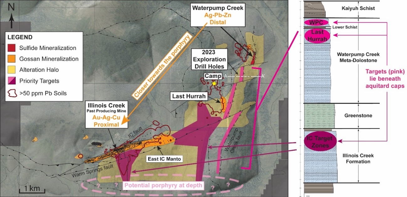
Figure 1. Plan map and stratigraphic column of the greater Illinois Creek region: including the past-producing the Illinois Creek Mine, and Waterpump Creek and Last Hurrah prospects. See our website for the A to A' Last Hurrah drill section.
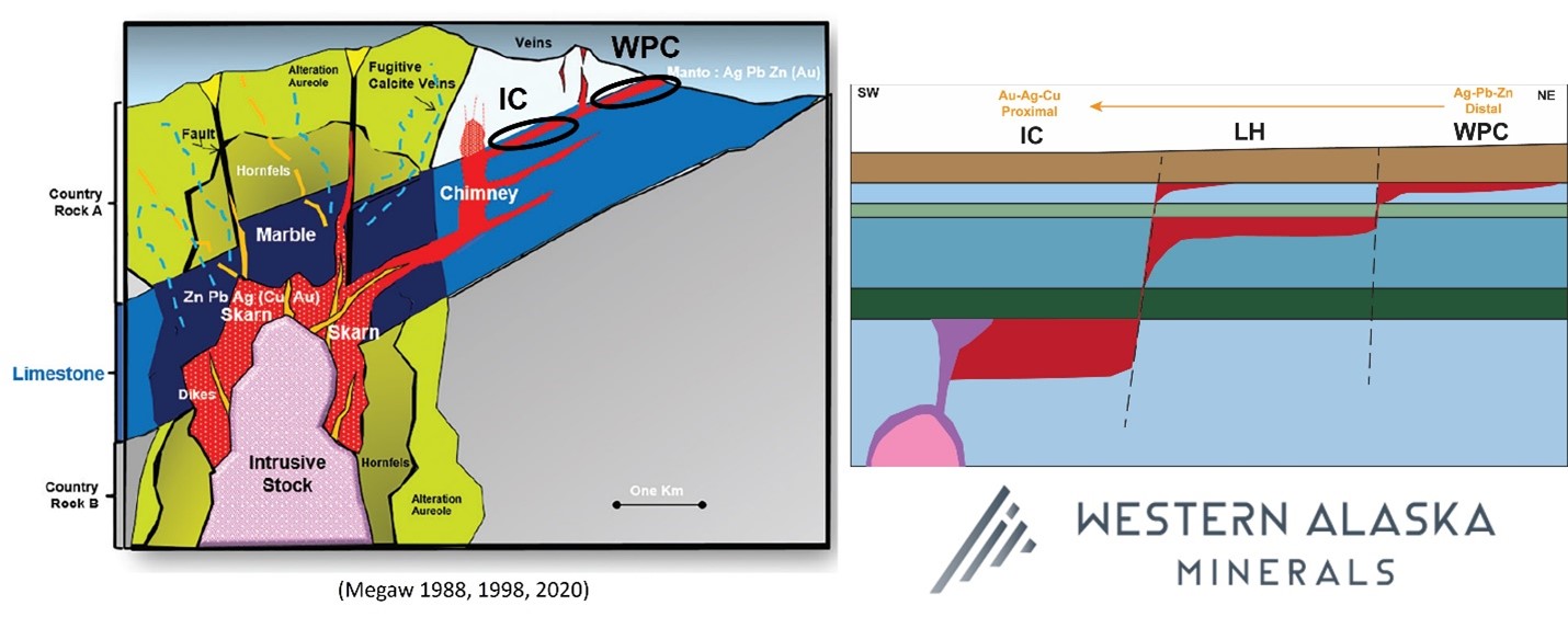
Figure 2. Left: Conceptual CRD model illustrated by world-renowned CRD expert/WAM Technical Advisor, Dr. Peter Megaw. Right: WAM's conceptual "stair-stepping" of mineralization moving progressively through different stratigraphic target horizons. Exploration is attempting to follow this from distal (WPC) through medial (LH) to proximal (ICM) and the undiscovered potential porphyry/skarn system.
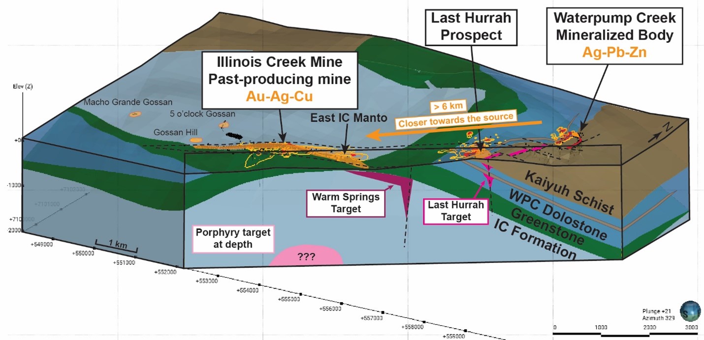
Figure 3. 3D Block view showing the sulfide and gossan zones, permissive horizons, and target zones.
The Company believes that CRD-style mineralization and alteration is continuous and increasing in intensity and scale to the south and west. This correlates well with the district zonation pattern which ranges from distal low temperature silver-zinc-lead mineralization at WPC to proximal higher temperature copper-gold-silver at IC as is expected in CRD systems.
This progressive metal zonation from Au-Ag-Cu at the Illinois Creek deposit to high grade Ag-Pb-Zn at WPC with alteration and mineralization occurring in multiple and progressively higher structural/stratigraphic "Stair Step" levels (Figure 2) demonstrates the excellent potential of the Illinois Creek District as a large scale CRD system.
"Continuity of mineralization from the source outward with gradually diminishing volume, often over several kilometers, has been recognized for over 100 years as a fundamental aspect of CRD systems, so it is highly probable we'll find the continuation of Waterpump Creek mineralization across the post-mineral fault," said Dr. Peter Megaw, Exploration Advisor to WAM. "Importantly, many CRD systems show "Christmas Tree" patterns of mineralization affecting more and more layers in the stratigraphy as the source is approached and it looks like we're beginning to see that progression at Last Hurrah".
Last Hurrah Drilling (Phase II)
- 2023 exploration drilling in this new zone showed strong and abundant CRD alteration, characterized by broad CRD-style surrounding "fugitive" carbonate veins, in nearly all drill holes. The modelled resistivity from the 2023 survey suggests that the alteration increases in size to the south and west of Last Hurrah towards the Illinois Creek mine.
- Anomalous Pb and Zn values coincide with the CRD alteration, however, no massive sulfides were intersected.
- BBQ rock" (UV fluorescent fugitive calcite) remains a key proximity vector to mineralization and was intersected in all but 2 Last Hurrah holes ( See Press Release of August 14 , 2023).
- The drilling and geophysical modelling at Last Hurrah shows conclusively that there are three key permissive CRD host rock stratigraphic units present and that mineralization seems to "stair-step" progressively from one to the other across the property from WPC to: Last Hurrah, Warm Springs Creek, and the Illinois Creek zone.
Visit the WPC page on our website to view the cross section.
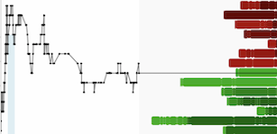
3D IP Geophysical Survey Modeling: Results show extensive alteration within three potential permissive carbonate packages.
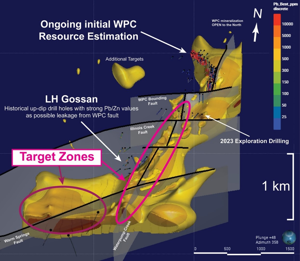
Figure 4. 3D view looking east of the 25 and 5 ohm-meter iso surfaces from the Dias 3D DCIP Survey and inversion.
A high-resolution 3-D resistivity and induced polarization survey ("3D IP") covering Waterpump Creek and Last Hurrah target areas was conducted by DIAS Geophysical during the summer field season. Inversion modeling reveals distinct structural, stratigraphic controls to CRD mineralization and outlines the increasing alteration halo to the south. Figure 4 above shows the modeled 25 ohm-m zone, which can be used as a proxy for alteration and the 5 ohm-meter zones that show district breaks that define syn- and post-mineralization structures.
- Detailed inversion modeling defines the fault structures that offset the WPC mineralization and the (likely) vertical north-south fault(s) that control the CRD mineralizing fluids.
- Importantly, the resistivity modeling shows a <25 ohm-meter signature that corresponds directly with extensive sanding and clay alteration surrounding the CRD mineralization.
- The IP modeling, in tandem with the drilling in WPC and Last Hurrah also shows an increasing scale in alteration to the south that extends through all three permissive carbonate horizons.
Waterpump Creek: Initial Resource Estimate (Phase 1 2023 drilling)
Five holes were drilled at Waterpump Creek, two step-out holes and three infill holes, for a total of 1706 meters.
2023 drilling returned more high-grade silver-lead-zinc infill and expansion drilling, sufficient for a preliminary NI 43-101 compliant resource estimate. The report is well-underway and is expected to be published in early 2024. Expansion highlights include:
- WPC23-29: 19.5 m @ 158 g/t (5.1 opt) Ag, 5.3% Pb, and 11.5% Zn
- WPC23-30: Cumulative 71.6 meters of multiple high-grade zones
- 22.0 m of 146 g/t Ag (4.7 opt), 3.3% Pb and 9.8% Zn
- 40.2 m of 262 g/t Ag (8.4 opt), 10.9% Pb and 4.5% Zn, including:
- 5.3 m of 729 g/t Ag (23.4 opt), 24.1% Pb and 3.1 % Zn, and
- 8.6 m of 493 g/t Ag (15.8 opt), 22.9% Pb and 2.6% Zn
- Extends the mineralization at least 45 meters down plunge to the south and demonstrates continuity of the system for 495 meters in length, cut off on the southern fault. See press release dated August 14.
Qualified Person
The Qualified Person who reviewed and approved the technical disclosure in this release is Andrew West, Certified Professional Geologist, a Qualified Person as defined under National Instrument 43-101. Mr. West is the Vice President for Western Alaska Minerals with a MS in Geology and 30 years of experience in mineral resources, mine, and exploration. He is a Certified Professional Geologist with the American Institute of Professional Geologists (AIPG CP-11759).
His review verified the technical data disclosed, including geology, sampling, analytical and QA/QC data underlying this news release, including reviewing the reports of ALS, methodologies, results, and all procedures undertaken for quality assurance and quality control in a manner consistent with industry practice.
About WAM
WAM is an Alaska and Arizona based company, listed on the TSX-V and focused on discovery of high-grade, district-scale ore systems in the historic Illinois Creek Mining District located in western Alaska. WAM's 100% owned claims cover 73,120 acres (114.25 square miles or 29,591 hectares), approximately 45 km from the Yukon River. WAM's land position encompasses at least five prospects, including the past producing Illinois Creek gold-silver mine, Waterpump Creek silver-lead-zinc deposit the Honker gold prospect and the Round Top copper prospect, all originally discovered by Anaconda Minerals Co. in the early 1980's. Since 2010, WAM, along with precursor Western Alaska Copper & Gold Company, has reassembled the Anaconda property package and been engaged in exploring the district.
On behalf of the Company
"Kit Marrs"
Kit Marrs
President & CEO
Phone: 520-200-1667
For further information please contact:
Vanessa Bogaert, Director of Corporate Communications/IR at
vanessa@westernalaskaminerals.com
Or visit our website at: www.westernalaskaminerals.com.
Forward Looking Information
Certain statements made, and information contained herein may constitute "forward looking information" and "forward looking statements" within the meaning of applicable Canadian and United States securities legislation. These statements and information are based on facts currently available to the Company and there is no assurance that actual results will meet management's expectations. Forward-looking statements and information may be identified by such terms as "anticipates", "believes", "targets", "estimates", "plans", "expects", "may", "will", "could" or "would". Forward-looking statements and information contained herein are based on certain factors and assumptions regarding, among other things, the estimation of mineral resources and reserves, the realization of resource and reserve estimates, metal prices, taxation, the estimation, timing and amount of future exploration and development, capital and operating costs, the availability of financing, the receipt of regulatory approvals, environmental risks, title disputes and other matters. While the Company considers its assumptions to be reasonable as of the date hereof, forward-looking statements and information are not guaranteeing of future performance and readers should not place undue importance on such statements as actual events and results may differ materially from those described herein. The Company does not undertake to update any forward-looking statements or information except as may be required by applicable securities laws.
Neither TSX Venture Exchange nor its Regulation Services Provider (as that term is defined in the policies of the TSX Venture Exchange) accepts responsibility for the adequacy or accuracy of this release.
SOURCE: Western Alaska Minerals Corp
View source version on accesswire.com:
https://www.accesswire.com/814186/western-alaska-minerals-refines-exploration-model-yielding-system-wide-targeting-at-illinois-creek
