


VANCOUVER, BC, March 14, 2024 /CNW/ - Sitka Gold Corp. ("Sitka" or the "Company") (TSXV:SIG) (FSE:1RF) (OTCQB:SITKF) is pleased to provide project updates for its portfolio of Gold, Silver and Copper properties located in proven, mining friendly jurisdictions in North America (see Figure 1).
Sitka's project portfolio includes the RC Gold project ("RC Gold") and OGI project ("OGI") located in Yukon, the Alpha Gold project ("Alpha Gold") located in Nevada, the Burro Creek project ("Burro Creek") located in Arizona and the Coppermine River project ("Coppermine River") located in Nunavut. Sitka's projects vary from grassroots and discovery stage properties to advanced stage projects that include the recent discovery of a significant gold deposit at its RC Gold project which is open for expansion in all directions. The Company's primary focus for 2024 is on its flagship RC Gold project where an initial inferred gold resource of 1.34 million ounces of gold (1) was recently announced and a winter diamond drilling program focused on expansion of this resource is currently underway. Results from drilling at the Alpha Gold Project in Nevada have been received and key permits have also recently been secured to allow for drilling at the Burro Creek project in Arizona and the Coppermine River project in Nunavut.
Sitka Gold Corp. is a well-funded mineral exploration company headquartered in Canada with approximately $7.5 million in the treasury. The company recently began trading on the TSX Venture Exchange (TSX-V) and delisted from the Canadian Securities Exchange (CSE).
")
"Since its inception, Sitka's goal was to curate a portfolio of highly prospective mineral properties that would provide diversification across key target minerals and mining friendly jurisdictions", said Cor Coe, Director and CEO of Sitka. "Having accomplished that, Sitka spent the past several years systematically advancing these properties through varying stages of exploration. The results of these efforts have led to multiple discoveries and milestones, the most recent being the advancement of RC Gold from a discovery hole to an initial mineral resource estimate of 1.34 million ounces of gold within just 12 months. With our main focus on growing that resource towards critical mass while exploring the several additional drill ready targets at RC Gold ripe for discovery, we are also excited to continue our exploration efforts at Alpha Gold where we have discovered a large Carlin-type gold system that has the potential to host a significant gold resource similar to other other deposits along the Cortez-trend where over 50 million ounces of gold has been discovered to date. With drill permits now in hand for Coppermine River and Burro Creek, along with a treasury of approximately $7.5 million, Sitka is well positioned to further unlock the potential within its mineral portfolio and create additional shareholder value."
The Company is currently conducting a winter diamond drilling program at its year-round road accessible RC Gold Project in Yukon as part of a 15,000 metre diamond drilling program planned for 2024. Recently drilled core from DDRCCC-24-057 where drilling is currently underway can be viewed in Figure 4. Current drilling is focused on stepping out from Hole 47 that was drilled in 2023 south of the current Blackjack gold deposit (900,000 ounces of gold at a grade of 0.83 g/t; see news release dated January 19, 2023). Hole 47 contained the best gold mineralized intersection to date on the property, returning 219.0 m of 1.34 g/t gold including 124.8 m of 2.01 g/t gold and 55.0m of 3.11 g/t gold. Drilling in 2024 will continue to focus on expanding the recently discovered Blackjack and Eiger gold deposits (with Eiger hosting 440,000 ounces of gold at a grade of 0.50 g/t, see news release dated January 19, 2023) that are approximately 1.5 kilometres apart (see Figures 2 and 3). Drilling will also be targeted to expand the Saddle Zone, located midway between the Blackjack and Eiger deposits, where the largest and strongest gold-in-soil anomaly on the property is located (see Figures 2 and 3) along with other prospective areas within the 386 square kilometre contiguous property that hosts 9 known intrusions that are all known to be gold bearing from previous work.
")
")
")
The project is located a two hour drive east of Dawson City and is accessed via the Klondike Highway and a network of industrial roads that service placer mines in the area. The RC Gold Property is located within the Tombstone Gold Belt (TGB) which is host to two producing mines, Kinross's Fort Knox Mine in Alaska and Victoria Gold's Eagle Mine in Yukon located approximately 50 kilometres east of RC Gold. The TGB has produced several significant new gold discoveries in recent exploration including the Blackjack and Eiger deposits at Sitka's RC Gold Project, Snowline Gold's Valley Gold deposit discovery, Banyan Gold's Aurmac deposit discovery and Victoria Gold's Raven deposit discovery.
The Alpha Gold property lies 40 km SSE of Nevada Gold Mines' Cortez complex, including the Pipeline, Cortez Hills and Goldrush tier one gold deposits and is located at the southeast end of the Cortez trend (Figure 5). Four holes totaling 1027.3 m were drilled in the 2023 program at Alpha (see Figure 6). The 2023 drilling and previous drilling produced broad gold intervals with abundant Carlin pathfinder elements in strong Carlin-type alteration in all drill holes (see Table 1).
")
The 2023 drilling and previous widely spaced drilling demonstrate that gold mineralization appears continuous along the 2.5 km segment of the Alpha anticline with encouraging evidence of higher-grade zones. An additional 4.5 km segment of the Alpha anticline continuing SSE to Frazier Creek remains untested by drilling. Four initial surface rock chip samples at Frazier Creek returned up to 0.775 g/t gold, greatly surpassing all surface gold from the Alpha NW area highlighting the potential of this area.. Drilling and geologic modelling continues to support a large Carlin-type gold system with extremely prospective untested targets and excellent potential for discovery of a high-grade core zone.
Table 1 – Alpha NW Drill Results greater than 0.2 g/t gold 2021 to 2023. Wide spaced drilling at Alpha has continued to intersect broad gold intervals. | ||||
HOLE ID | FROM (m) | LENGTH (m)* | GOLD (g/t) | COMMENTS |
AG23-13 | 117.3 | 4.57 | 0.34 | This release |
AG23-13 | 135.6 | 6.10 | 0.29 | This release |
AG23-14 | 350.5 | 9.14 | 0.50 | This release |
incl AG23-14 | 353.6 | 3.05 | 0.82 | This release |
AG23-15 | 96.0 | 19.81 | 0.41 | This release |
incl AG23-15 | 100.6 | 7.62 | 0.55 | This release |
AG23-16 | 143.3 | 28.96 | 0.38 | This release |
incl AG23-16 | 160.0 | 10.67 | 0.49 | This release |
AG21-02 | 89.9 | 3.05 | 0.25 | May 6, 2021 News Release |
AG21-02 | 155.4 | 6.10 | 0.24 | May 6, 2021 News Release |
AG21-03 | 65.5 | 1.52 | 0.25 | May 6, 2021 News Release |
AG21-03 | 83.8 | 4.57 | 0.28 | May 6, 2021 News Release |
AG21-03 | 190.5 | 1.52 | 0.36 | May 6, 2021 News Release |
AG21-04* | <0.2 | Sep 26, 2021 News Release | ||
AG21-05** | 118.9 | 12.19 | 0.41 | Sep 26, 2021 News Release |
AG21-06* | <0.2 | Nov 16, 2021 News Release | ||
AG21-07 | 62.5 | 4.57 | 0.28 | Nov 16, 2021 News Release |
AG21-07 | 111.5 | 4.57 | 0.34 | Nov 16, 2021 News Release |
AG21-07 | 125.0 | 6.10 | 0.27 | Nov 16, 2021 News Release |
AG21-07 | 149.4 | 3.05 | 0.29 | Nov 16, 2021 News Release |
AG21-08 | 262.1 | 1.52 | 0.44 | Nov 16, 2021 News Release |
AG21-08 | 333.8 | 3.05 | 0.38 | Nov 16, 2021 News Release |
AG21-08 | 339.9 | 9.14 | 0.60 | Nov 16, 2021 News Release |
incl AG21-08 | 344.4 | 3.05 | 1.10 | Nov 16, 2021 News Release |
AG21-08 | 364.2 | 3.05 | 0.41 | Nov 16, 2021 News Release |
AG22-09 | 115.82 | 3.05 | 0.30 | Oct 6, 2022 News Release |
AG22-09 | 137.2 | 15.24 | 0.42 | Oct 6, 2022 News Release |
AG22-09 | 149.4 | 6.10 | 0.23 | Oct 6, 2022 News Release |
AG22-10 | 202.7 | 3.05 | 0.27 | Oct 6, 2022 News Release |
AG22-10 | 210.3 | 48.77 | 0.70 | Oct 6, 2022 News Release |
incl AG22-10 | 211.8 | 21.34 | 1.21 | Oct 6, 2022 News Release |
incl AG22-10 | 225.6 | 1.52 | 4.62 | Oct 6, 2022 News Release |
AG22-11 | 483.1 | 12.19 | 0.50 | Feb 22, 2023 News Release |
AG22-11 | 483.1 | 1.52 | 2.32 | Feb 22, 2023 News Release |
AG22-12*** | <0.2 | Feb 22, 2023 News Release | ||
*Hole located off anticline axis; ** Lost hole in mineralization; ***Lost hole above target |
*Intervals are drilled core length, as insufficient drilling has been completed at this time to determine true widths |
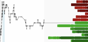
The 2023 drilling at Alpha greatly advanced the definition of structural controls to mineralization along the Alpha anticline and highlighted prime areas for targeting the deeper increasingly prospective Wenban 5 correlative host. Sitka has completed 5143.5 m of drilling in 15 holes since 2021 on the northwest end of the 7 km Alpha anticline. A longitudinal section of the 2.5 km segment where the drilling has occurred is shown in Figure 7 with gold and in Figure 8 with arsenic. The Alpha anticline lies in a down-dropped area east of a lower plate window as Goldrush does. All drilling at the Alpha project has occurred in the northwest portion of the project, except AG20-01. Drilling near the Alpha anticline axis has yielded significant gold intercepts, so far testing only the shallow Horse Canyon host stratigraphy. The Horse Canyon is the uppermost of two important carbonate rock units that are host to gold deposits in the Cortez Trend, the deeper carbonate rock unit is the Wenban 5.
Higher gold grades up to 4.62 g/t in Hole AG22-10 (see news release of October 6, 2022) close to steep dike-filled structures along Alpha anticline support an interpretation that main stage gold deposition relates to host rock intersecting the anticline hinge and to cross-structures along it. This important relationship and association with higher grades in drilling to date at the project provides many emerging structural/stratigraphic targets in the Horse Canyon Fm and the untested Wenban 5 equivalent host rocks which are highlighted in Figure 7. The Wenban 5 is the equivalent of the horizon that hosts most of the world class Goldrush ore body.
")
. The ideal location at the intersection of structure with permissive host rock is possible along the length of the section with more precise targeting. (CNW Group/Sitka Gold Corp.)")
")
The Company is pleased to announce that Arctic Copper Corp (ACC), a wholly owned subsidiary of Sitka Gold Corp, has received a Land Use Permit and a water permit to allow diamond drilling on the Company's Coppermine River Project.
Arctic Copper Corp currently holds approximately 12,000 hectares in 2 separate claim blocks in the Coppermine River District of Nunavut. The Copper Leaf showing, a new discovery made in 2015 by Arctic Copper personnel, is located approx. 60 km southwest of Kugluktuk and has never been tested by drilling (see Figure 9 and 11).
")
The Copper Leaf showing consists of strong massive and disseminated sediment-hosted copper sulphide mineralization in the Husky Creek Sandstone Formation. The mineralization appears to lie proximal to a major gabbro dyke that trends north-south for more than 12 km. Grab samples from the Copper Leaf showing returned values of up to 13.45% copper and up to 65 g/t silver in sandstone interpreted to be brought to surface by frost heave action (see Figure 11). A single line gravity survey (see Figure 10) was conducted over the Copper Leaf showing in 2015 and revealed a strong gravity anomaly 90 m wide located proximal to the Gabbro Dyke. An expanded gravity survey conducted in 2019 suggested significant strike potential along the east flank of the gabbro dyke for more than 400 m.
. The gravity survey identified a sustained gravity anomaly to the east of the gabbro dyke where mineralized samples were collected from frost boils. The resulting gravity high area is interpreted as an increase of density resulti (CNW Group/Sitka Gold Corp.)")
The mineral occurrences at Copper Leaf display similarities to other major world renown sediment hosted copper deposits such as the Kamoa-Kakula copper deposits in the Democratic Republic of Congo (DRC). The similar stratiform style, similar age, and similar depositional and tectonic environment indicate the potential for large high grade copper deposits to occur at Copper Leaf. The current published mineral resource at Kamoa-Kikula is 1.3 billion Mt grading 2.70% copper yielding 77.4 billion lbs of contained copper(1)(2). Other analogues to Copper Leaf include the Keweenaw Copper deposits in the United States (3.5 billion pounds of copper Indicated Resource (3)).
(1) | Gilchrist, G., Pri.Sci.Nat.SACNASP, and Witley, G., Pri.Sci.Nat.SACNASP (Qualified Person): Kamoa and Combined Kakula Indicated and Inferred Mineral Resource. Effective Date December 31, 2022. |
(2) | These figures are for discussion purposes and do not imply that Arctic Copper Corp. has such copper deposits at this time. |
(3) | Carl Michaud P.Eng. et al, Preliminary Economic Assessment White Pine North Project Michigan, USA, NI43.101 compliant. July 12, 2023. |
(4) | Close, Scott, M.Sc.,P.Geo., Technical Report of the ACG,ACJ and ACRAE Claim Blocks Coppermine River Project for Arctic Copper Corp., December 15, 2015; Available at www.sitkagoldcorp.com |
")
The Burro Creek Gold and Silver Project is located 105 km by road southeast of Kingman, Arizona and is accessed via a 1.6 km dirt road west off Highway 93. The project covers an area of approximately 287 hectares and consists of four centrally located patented mineral claims and an additional 35 lode claims. The Property covers a low-sulphidation epithermal vein system that has been traced for over 1.7 km and exhibits widths of up to 45 metres.
The Company has received its drill permit to further explore its Burro Creek Property where a historical gold and silver resource (indicated and inferred) has been identified(1, 2) (see Table 2 and news releases Nov 12, 2019) within the Burro vein which is a low sulphidation epithermal gold-silver vein. Previous drilling by Sitka Gold confirmed the mineralization from the historical resource continues to the southern boundary of the patented mining claims (see Figure 13). The recently received drill permit now enables drill testing south of the historical resource beyond the patented mining claims. Previous work including surface geochemistry (see Figure 11), prospecting and geological mapping indicates the Burro vein continues for at least an additional 1.5 km to the south.
 soil sampling at Burro Creek. The projection of the Burro vein to the south is obscured by a thin cover of volcanic rocks. MMI surveys were conducted using this technique which is a proven advanced geochemical exploration tool used to target buried mineral deposits. The results from this survey indicate the Burro Vein continues south of the existing resource area for at least 1.3 kilometres. (CNW Group/Sitka Gold Corp.)")
The historical mineral resource estimate of the Burro deposit is based on 87 reverse circulation (RC) and diamond drill holes and 9 sampled adits totaling 6,672m and 2,682 assays. Mineralization was constrained within a 3-dimensional geological solid created using Gemcom software. Practices consistent with CIM (2005) were applied to the generation of the historical mineral resource estimate and the parameters of the modeling are fully described in the NI 43-101 report referenced below.
Previous reverse circulation, diamond drilling and underground development conducted on the property outlined an historical indicated resource of 2,331,871 tonnes grading 1.01 g/t Au and 36.77 g/t Ag (yielding 122,491 ounces at a 1.63 g/t Au equivalent) and an historical inferred resource of 2,247,069 tonnes grading 0.60 g/t Au and 30.95 g/t Ag (yielding 81,304 ounces at a 1.13 g/t Au equivalent), both using a cut-off grade of 0.50 g/t Au(1). The historical results reported in the NI 43-101 technical report are considered by management to be reliable and relevant, though not conforming to current NI 43-101 standards (1,2). The Company is not treating the historical estimate as current mineral resources or mineral reserves.
The Property was fully permitted to commence production in 1988 but the production decision was deferred due to a decline in the price of gold and silver(1). At that time, the intent was to place the Burro gold and silver deposit into production and continue to expand the resource through exploration funded by the ensuing profits.
(1) Pautler, J. (October 27, 2018) Technical Report on the Burro Creek Project |
Table 2: Historic Resource Summary | ||||||||
HISTORIC INDICATED RESOURCE:** | ||||||||
AuEq* | Gold | Silver | Gold Equivalent | |||||
Cut-Off | Tonnes | Grade (g/t) | Ounces | Grade | Ounces | Grade (g/t) | Ounces | |
0.5g/t | 2,331,871 | 1.01 | 75,567 | 36.77 | 2,756,778 | 1.63 | 122,491 | |
HISTORIC INFERRED RESOURCE:** | ||||||||
AuEq* | Gold | Silver | Gold Equivalent | |||||
Cut-Off | Tonnes | Grade (g/t) | Ounces | Grade | Ounces | Grade (g/t) | Ounces | |
0.5g/t | 2,247,069 | 0.6 | 43,243 | 30.95 | 2,236,113 | 1.13 | 81,304 | |
*AuEq metal prices: US$846.00/oz gold, US$14.40/oz silver (3-year average as at January 31, 2011) | ||||||||
** J.Pautler, NI43.101 Technical Report on the Burro Creek Project, Oct 27, 2018 | ||||||||
Recent exploration by Sitka in 2020 included 10 drill holes to define the on-strike continuity of the Burro Vein within the bounds of the patented claims (Figure 12). The results confirmed that the vein extends to the southern limits of the patented claims where Mobile Metal Ion (MMI) geochemical surveys conducted in 2013 indicate that the Burro Vein likely continues southward beneath a thin cover of volcanic rocks. Hole 19-56 intersected 1.14 g/t gold and 42.94 g/t silver over a core length of 41.08 m. Drilling is now permitted to test for the extension of the Burro Vein which could add significant potential to the property.
Table 3: Summary of drill hole highlights from the 2019 through 2020 diamond drilling program | |||||||
Drill Hole ID | Interval | Core | Gold | Silver | News Release Date | ||
From (m) | To (m) | Length (m) | (g/t) | (g/t) | Friday, January 17, 2020 | ||
BC19-56 | 15.03 | 56.11 | 41.08 | 1.14 | 42.94 | Friday, January 17, 2020 | |
including | 37.34 | 56.11 | 18.77 | 2.20 | 27.79 | Friday, January 17, 2020 | |
including | 42.67 | 43.74 | 1.07 | 17.55 | 33.00 | Friday, January 17, 2020 | |
BC19-57 | 0.00 | 50.63 | 50.63 | 1.10 | 35.97 | Friday, January 17, 2020 | |
including | 10.70 | 22.40 | 11.70 | 3.23 | 72.86 | Friday, January 17, 2020 | |
including | 18.93 | 20.21 | 1.28 | 16.85 | 77.00 | Friday, January 17, 2020 | |
BC19-58 | 29.41 | 54.41 | 25.00 | 0.37 | 83.99 | Friday, January 17, 2020 | |
including | 44.50 | 50.90 | 6.40 | 0.75 | 119.37 | Friday, January 17, 2020 | |
BC19-59 | 26.52 | 53.64 | 27.12 | 0.62 | 79.58 | Friday, January 17, 2020 | |
including | 47.85 | 53.64 | 5.79 | 2.08 | 23.69 | Friday, January 17, 2020 | |
BC20-60 | 36.48 | 48.37 | 11.89 | 1.02 | 66.66 | Thursday, February 20, | |
including | 36.48 | 39.84 | 3.36 | 1.76 | 52.26 | Thursday, February 20, | |
BC20-61 | 106.55 | 134.72 | 28.17 | 1.01 | 10.91 | Thursday, February 20, | |
including | 128.62 | 132.95 | 4.33 | 3.12 | 6.37 | Thursday, February 20, | |
including | 129.84 | 131.24 | 1.40 | 6.24 | 8.00 | Thursday, February 20, | |
BC20-62 | 116.73 | 122.77 | 6.04 | 0.94 | 14.16 | Tuesday, April 14, 2020 | |
including | 118.56 | 121.30 | 2.74 | 1.45 | 17.44 | Tuesday, April 14, 2020 | |
130.33 | 132.89 | 2.56 | 0.62 | 56.80 | Tuesday, April 14, 2020 | ||
BC20-63 | 140.96 | 142.00 | 1.04 | 1.27 | 1.00 | Tuesday, April 14, 2020 | |
BC20-64 | no significant results | Tuesday, April 14, 2020 | |||||
BC20-65 | no significant results | Tuesday, April 14, 2020 | |||||
*Intervals are drilled core length, as insufficient drilling has been completed at this time to determine true widths |
")
1. | A NI 43-101 report dated October 27, 2018 titled "Technical Report on the Burro Creek Project" was commissioned by Sitka Gold Corp and has been completed by J. Pautler, P. Geo., an independent qualified person. This report has been filed on SEDAR. |
2. | The Property contains an historical mineral resource estimate (the Burro Deposit) as defined by the National Instrument 43-101 Standards for Disclosure for Mineral Projects and is not considered by Sitka Gold Corp. to be a current mineral resource because a qualified person has not completed sufficient work to reclassify it as such. The indicated and inferred historical mineral resource estimate was prepared for Northern Freegold Resources Ltd. in November, 2010 in compliance with the standards of NI 43-101 at the time by Dr. A. Armitage, Ph.D., P.Geol., and J. Campbell, B.Sc., P.Geo. of GeoVector Management Inc., an Ottawa, Ontario based consulting firm specializing in resource estimation, project assessment, and project management. The historical resource estimate was contained in an NI 43-101 compliant technical report titled "Technical report on the Burro Creek Project, dated January 31, 2011 by Pautler, J.M., Armitage, A. and Campbell, J. and filed on SEDAR on February 28, 2011 (www.sedar.com) (1). |
Sitka continues to explore the OGI property for its Sedex Pb-Zn-Ag potential as well as for Intrusion Related Gold System occurrences. The OGI property is strategically located at the western end of the Tombstone Gold Belt immediately north of the Brewery Creek deposit, recently acquired Victoria Gold, and 20 km west of the Mike Lake Project, recently acquired by Prospector Resources (Figure 14) Previous exploration has included soil geochemical surveys, airborne magnetics (done by the Geological Survey of Canada), gravity geophysics, stream sediment sampling, geological mapping and a small rotary air blast (RAB) drilling program. Previous soil surveys have produced areas of interest for follow-up exploration.
")
The RC Gold Project consists of a 386 square kilometre contiguous district-scale land package located in the heart of Yukon's Tombstone Gold Belt. The project is located approximately 100 kilometres east of Dawson City with a 5,000 foot paved runway and is accessed via a secondary gravel road from the Klondike Highway which is usable year-round and is an approximate 2 hour drive from Dawson. It is the largest consolidated land package strategically positioned mid-way between Victoria Gold's Eagle Gold Mine - Yukon's newest gold mine which reached commercial production in the summer of 2020 - and Victoria Gold's former producing Brewery Creek Gold Mine.
On January 19, 2023 Sitka Gold announced an Initial Mineral Resource Estimate prepared in accordance with National Instrument 43-101 ("NI 43-101") guidelines for the RC Gold Property of 1,340,000 ounces of gold(1). The road accessible, pit constrained Mineral Resource is classified as inferred and is contained in two near/on-surface zones: The Blackjack and Eiger deposits. Both of these deposits are at/near surface, are potentially open pit minable and amenable to heap leaching, with initial bottle roll tests indicating that the gold is not refractory and has high gold recoveries of up to 94% with minimal NaCN consumption (see News Release July 13, 2022). The Mineral Resource estimate is presented in the following table at a base case cut-off grade of 0.25 g/t Au:
RC Gold Inferred Mineral Resource Estimate
COG g/t Au | Blackjack Zone | Eiger Zone | Combined | ||||||||
Tonnes | Au g/t | 0z Au | Tonnes | Au g/t | 0z Au | Tonnes | Au g/t | 0z Au | |||
0.20 | 35,798 | 0.80 | 921 | 32,523 | 0.45 | 471 | 68,321 | 0.63 | 1,391 | ||
0.25 | 33,743 | 0.83 | 900 | 27,362 | 0.50 | 440 | 61,105 | 0.68 | 1,340 | ||
0.30 | 31,282 | 0.88 | 885 | 22,253 | 0.55 | 393 | 53,535 | 0.74 | 1,279 | ||
0.35 | 29,065 | 0.92 | 860 | 17,817 | 0.60 | 344 | 46,882 | 0.80 | 1,203 | ||
0.40 | 26,975 | 0.96 | 833 | 14,506 | 0.66 | 308 | 41,481 | 0.86 | 1,140 | ||
Notes |
1. Mineral resource estimate prepared by Ronald G. Simpson of GeoSim Services Inc. with an effective date of January 19, |
2023. Mineral Resources are classified using the 2014 CIM Definition Standards. |
2. The cut-off grade of 0.25 g/t Au is believed to provide a reasonable margin over operating and sustaining costs for open-pit |
mining and processing |
3. Mineral resources are constrained by an optimised pit shell using the following assumptions: US$1800/oz Au price; a 45° |
pit slope; assumed metallurgical recovery of 85%; mining costs of US$2.00 per tonne; processing costs of US$8.00 per |
tonne; G&A of US$1.50/t. |
4. Mineral resources are not mineral reserves and do not have demonstrated economic viability. |
5. Totals may not sum due to rounding. |
To date, 54 diamond drill holes have been drilled into this system for a total of approximately 18,877 metres including 16-holes totalling 6,515 metres in 2023 focused on expanding the initial resource. The resource expansion drilling in 2023 produced results of up to 219.0 m of 1.34 g/t gold including 124.8 m of 2.01 g/t gold and 55.0 m of 3.11 g/t gold in drill hole DDRCCC-23-047 at Blackjack (see news release dated September 26, 2023).
*For more detailed information on the underlying properties please visit our website at www.sitkagoldcorp.com.
Exploration on the Property has mainly focused on identifying an intrusion-related gold system ("IRGS"). The property is part of the Tombstone Gold Belt which is the prominent host to IRGS deposits within the Tintina Gold Province in Yukon and Alaska. Notable deposits from the belt include: Fort Knox Mine in Alaska with current Proven and Probable Reserves of 230 million tonnes at 0.3 g/t Au (2.471 million ounces; Sims 2018)(1); Eagle Gold Mine with current Measured and Indicated Resources of 233 million tonnes at a grade of 0.57 g/t Au at the Eagle Main Zone (4.303 million ounces; Harvey et al, 2022)(2); the Brewery Creek deposit with current Indicated Mineral Resource of 22.2 million tonnes at a gold grade of 1.11 g/t (0.789 million ounces; Hulse et al. 2020)(3); the Florin Gold deposit, located adjacent to Sitka's RC Gold project, with a current Inferred Mineral Resource of 170.99 million tonnes grading 0.45 g/t (2.47 million ounces; Simpson 2021)(4) and the AurMac Project with an Inferred Mineral Resource of 347.49 million tonnes grading 0.63 gram per tonne gold (7.00 million ounces)(5).
(1) | Sims J. Fort Knox Mine Fairbanks North Star Borough, Alaska, USA National Instrument 43-101 Technical Report. June 11, 2018. https://s2.q4cdn.com/496390694/files/doc_downloads/2018/Fort-Knox-June-2018-Technical-Report.pdf |
(2) | Harvey N., Gray P., Winterton J., Jutras M., Levy M.,Technical Report for the Eagle Gold Mine, Yukon Territory, Canada. Victoria Gold Corp. December 31, 2022. https://vgcx.com/site/assets/files/6534/vgcx_-_2023_eagle_mine_technical_report_final.pdf |
(3) | Hulse D, Emanuel C, Cook C. NI 43-101 Technical Report on Mineral Resources. Gustavson Associates. May 31, 2020. https://www.goldenpredator.com/_resources/Brewery-Creek_NI-43-101-05OCT2020-File.pdf |
(4) | Simpson R. Florin Gold Project NI 43-101 Technical Report. Geosim Services Inc. April 21, 2021. https://sedar.com/GetFile.do?lang=EN&docClass=24&issuerNo=00005795&issuerType=03&projectNo=03236138&docI d=4984158 |
(5) | Banyan Gold News Release Dated February 7, 2023 (Technical Report to be filed within 45 days of news release) https://banyangold.com/news-releases/2024/banyan-announces-7-million-ounce-gold-updated-mineral-resource-estimate-aurmac-project-yukon-canada/ |
Sitka Gold will be attending and/or presenting at the following events*:
- Swiss Mining Institute, Zurich, Switzerland: March 20 - 21, 2024
- 121 Mining Investment, London, England: May 16-17, 2024
- Takestock Investor Forum, Stampede Event, Calgary, Alberta: July 3, 2024
*All events are subject to change |
Sitka Gold Corp. is a well-funded mineral exploration company headquartered in Canada with approximately $7.5 million in the treasury. The Company is managed by a team of experienced industry professionals and is focused on exploring for economically viable mineral deposits with its primary emphasis on gold, silver and copper mineral properties of merit. Sitka is currently exploring its flagship RC Gold Project within the Tombstone Gold Belt in the Yukon Territory. The company is advancing the Alpha Gold Project in Nevada and has drill permits for its Burro Creek Gold and Silver Project in Arizona and the Coppermine River Project in Nunavut.
The scientific and technical content of this news release has been reviewed and approved by Cor Coe, P.Geo., Director and CEO of the Company, and a Qualified Person (QP) as defined by National Instrument 43-101.
ON BEHALF OF THE BOARD OF DIRECTORS OF
SITKA GOLD CORP.
"Donald Penner"
President and Director
This release includes certain statements and information that may constitute forward-looking information within the meaning of applicable Canadian securities laws. Forward-looking statements relate to future events or future performance and reflect the expectations or beliefs of management of the Company regarding future events. Generally, forward-looking statements and information can be identified by the use of forward-looking terminology such as "intends" or "anticipates", or variations of such words and phrases or statements that certain actions, events or results "may", "could", "should", "would" or "occur". This information and these statements, referred to herein as "forward–looking statements", are not historical facts, are made as of the date of this news release and include without limitation, statements regarding discussions of future plans, estimates and forecasts and statements as to management's expectations and intentions with respect to, among other things, the use of the proceeds raised under the Offering and the Company's anticipated work programs.
In making the forward-looking statements in this news release, the Company has applied several material assumptions, including without limitation, that the Company will complete its anticipated work programs and use the proceeds of the Offering as currently anticipated.
These forward–looking statements involve numerous risks and uncertainties and actual results might differ materially from results suggested in any forward-looking statements. These risks and uncertainties include, among other things, market uncertainty, the results of the Company's anticipated work programs and that the Company will not use the proceeds of the Offering as currently anticipated.
Although management of the Company has attempted to identify important factors that could cause actual results to differ materially from those contained in forward-looking statements or forward-looking information, there may be other factors that cause results not to be as anticipated, estimated or intended. There can be no assurance that such statements will prove to be accurate, as actual results and future events could differ materially from those anticipated in such statements. Accordingly, readers should not place undue reliance on forward-looking statements and forward-looking information. Readers are cautioned that reliance on such information may not be appropriate for other purposes. The Company does not undertake to update any forward-looking statement, forward-looking information or financial out-look that are incorporated by reference herein, except in accordance with applicable securities laws. We seek safe harbor.
")
![]() View original content to download multimedia:https://www.prnewswire.com/news-releases/sitka-gold-provides-update-on-its-north-american-gold-silver-and-copper-assets-302089388.html
View original content to download multimedia:https://www.prnewswire.com/news-releases/sitka-gold-provides-update-on-its-north-american-gold-silver-and-copper-assets-302089388.html
SOURCE Sitka Gold Corp.

![]() View original content to download multimedia: http://www.newswire.ca/en/releases/archive/March2024/14/c3306.html
View original content to download multimedia: http://www.newswire.ca/en/releases/archive/March2024/14/c3306.html
